


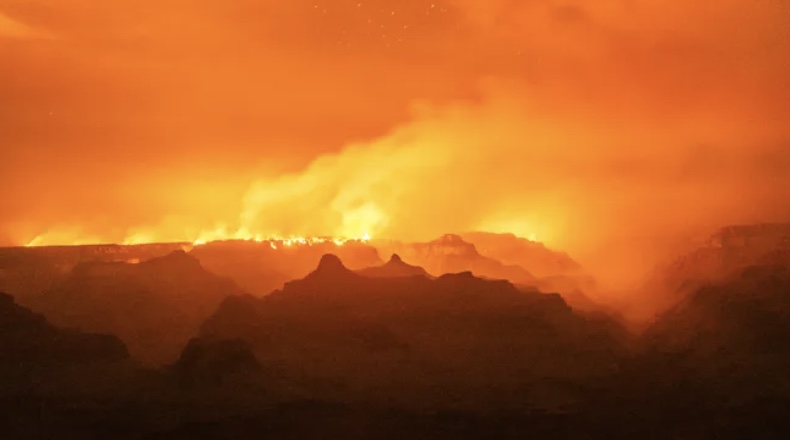
The White Sage Fire and Dragon Bravo Fire have forced 100 miles of the Arizona Trail to close from the South Kaibab Trailhead (South Rim of Grand Canyon) to Stateline Campground (northern terminus). Both fires started from lightning strikes in July and are being actively managed by the Kaibab National Forest, Grand Canyon National Park, and Bureau of Land Management. Highway 67 is closed, as well as all trails, dirt roads, and campgrounds north of the South Kaibab Trailhead. Please avoid the AZT north of the Grand Canyon's South Rim until further notice, and check back for updates.
Read More
Location
- Winter Road Trailhead to the Stateline Trailhead
Length
- 10.6 miles
Southern Access Point: Winter Road Trailhead
- GPS Coordinates: 36.91775° N, 112.10707° W
Access
From US 89A, at House Rock Road, 13.7 miles east of Jacob Lake, turn north on House Rock Road for 15.6 miles to Winter Road (BLM Road 1025). Turn left (west) on Winter Road for 3.7 miles to the AZT, where a large metal AZT sign indicates the trailhead.
Northern Terminus: Stateline Trailhead & Campground
- GPS Coordinates: 37.00112° N, 112.03499° W
Access
It may help to set your odometer to zero in Page, Arizona. From Page, head west on AZ 98 for 2.5 miles to US 89 and turn right (north). At mile 6.4, you’ll pass Wahweap Marina, which offers camping. Cross the state line at mile 13. At mile 38 from Page, just after mile marker 25, you’ll pass through a roadcut and the highway will begin a big, sweeping curve to the right. At the end of the guardrail on the left, turn left (south) onto a dirt road. This is 0.2 miles south of mile marker 26 (from Kanab, this turnoff is about 36 miles “south” according to signs—actually geographically east—on US 89). Follow the dirt road for 10 miles, and then turn right (west) onto a well-graded dirt road. Continue 0.2 miles to a parking area, restrooms, and several campsites. The trailhead is on the left as you drive in. Park in designated spots only.
Trail Route Description
Passage 43 stretches from Winter Road to the Utah border, marking the end of the AZT. On the eastern flank of Buckskin Mountain, this spectacular final section returns to the high-desert ecosystem of small cacti, colorful shrubs, and scraggly piñon and juniper trees. This short passage follows singletrack and features sweeping views of Utah to the north, and the colorful Vermilion Cliffs to the east.
Along this passage the trail rolls in and out of washes, crosses dirt roads, and descends to a gentle valley. It rises and falls through North Larkum Canyon and ascends to a scenic ridge with outstanding views of Utah to the northeast. Here, you will see craggy pink peaks, unique rock formations, and the psychedelic swirling sandstone of the Vermillion Cliffs.
The last two miles of this passage offer a stunningly dramatic conclusion. The trail descends through switchbacks along a grassy hillside with panoramic views and vibrant wildflowers in bloom in the spring.
After descending the switchbacks, the trail continues northeast over a sagebrush-covered valley to a low, rocky ridge. On the other side of this ridge, the trail descends to the Arizona/Utah border at the Stateline Trailhead and Campground.
Thru-hikers may head over to the northern terminus to snap their finishing photo and celebrate the completion of an epic journey!
Although the Utah border marks the official end of the AZT, the journey can still go on. If you find yourself enticed by the colorful canyons ahead of you, let this mark the start of the next adventure further north!
Difficulty
- Easy
Season(s)
- Spring, Summer and Fall
- Current weather forecast
Water
There is a good water source at the beginning of this passage as well as about half way through the passage. Check the online Arizona Trail Water Report for current information at https://aztrail.org/explore/water-sources/.
Notes/Warnings:
- All water along this passage should be purified prior to use.
- The Arizona Trail is marked with brown fiberglass posts with an Arizona Trail decal near the top.
Resources
- MAP
- PROFILE
- TRACK
- Waypoints: GPS | MP
- Arizona Euro-American History
- USGS Topographic Maps: Coyote Buttes and Pine Hollow Canyon.
- Kaibab National Forest map.
- BLM Information Center maps.
For more information
- The Passage Steward
- Vermilion Cliffs National Monument, 345 E Riverside Dr., St George, UT (435) 688-3240.
- Kaibab Plateau Visitor Center, Jacob Lake, AZ (928) 643-7298.
- BLM Information Center (602) 417-9300.
Current Passage Info

Passage 43 Reopens After Five-Month Fire Closure
December 23, 2020
The Bureau of Land Management's Arizona Strip Field Office recently rescinded the fire closure order that has kept the Buckskin Mountain Passage off-limits since the Pine Hollow Fire started in July 2020. The northernmost 10.6 miles of trail between Winter Road and Stateline Campground are open again, but all Arizona Trail adventurers should use caution within the burn zone. Falling trees, unstable soils, and the possibility of flash floods during rain storms present unnecessarily hazardous conditions. Please report any trail conditions in need of repair to the ATA using the Trail Conditions Form online, and we'll take care of it as soon as possible.
Read More

Northern Terminus Monument
May 8, 2018
On Saturday, May 5 a crew of stonemasons from Payson met with Passage 43 Trail Steward Paul Ostapuk at the Stateline Campground on the Arizona/Utah border to construct an official northern terminus monument. For anyone who has completed the AZT or visited this location, you know it's impossible to determine where the trail ends. Not anymore! Carlos Rodriguez (RB Stonework) and his crew expertly crafted a sandstone monument that matches the dimensions of the southern terminus marker on the US/Mexico border. But instead of concrete and steel, this marker is made from natural rock that blends perfectly with the surrounding landscape. They completed the project on Sunday, May 6 just in time to see a northbound thru-hiker finish his 800-mile journey. This project was made possible through support from the Bureau of Land Management and Arizona Trail Association members, donors and volunteers.
Read More
