


East Greenwich News (January 31, 2021) by Jonathan Malone It was hot, it was dry, and I was afraid that I was running out of water. I had been hiking through the high plateau desert in Arizona for three days and I had seen only a handful of people, lots of cows, and a few horses. I had heard elk and coyotes, but had not yet seen any of them. I was deep in the wilderness, there were few people, and my water supply was worrisome. I chose to be in this place. In September I backpacked for approximately 100 miles of the wilderness of Arizona. Hiking and backpacking are things I love to do, and I have gone on many solo and group trips in the Adirondack Mountains in New York and the White Mountains in New Hampshire as well as other areas of the Northeast. I love taking time to be in the forest, by the streams and lakes, and surrounded by the mountains. This year I opted for something completely new to me; I decided to hike one small portion of the 800-mile Arizona Trail. I started just north of Flagstaff and headed to the North Rim of the...
Read More
Location
- Cedar Ranch to Moqui Stage Station
Length
- 27.6 miles
Resources
- MAP
- PROFILE
- TRACK
- Waypoints: GPS | MP
- Arizona Euro-American History
- USGS Topographic Maps: SP Mountain, Chapel Mountain, Lockwood Canyon and Peterson Flat.
- Coconino National Forest map.
- Kaibab National Forest map.
- BLM Information Center maps.
Southern Access Point: Cedar Ranch
- GPS Coordinates: 35.54733° N, 111.78292° W
Access
From Flagstaff drive north on US 180 about 33.0 miles and turn right (east) onto FR 417 near mile marker 248 (if you reach the Kaibab National Forest sign, you’ve gone too far by 0.4 miles). Continue 5.2 miles to a point just a short distance north of Cedar Ranch Headquarters, where a side road (FR 9008A) leaves FR 417 to the left. The next passage begins here and follows FR 417 to the west (back along the road you just drove down).
Northern Access Point: Moqui Stage Station
- GPS Coordinates: 35.78743° N, 111.87562° W
Access
From the intersection of US 180 and AZ 64 in the town of Valle, go north on AZ 64 for 11 miles to FR 320 (mile marker 224). Turn right (east) onto FR 320 and drive 16 miles to an intersection with FR 301. Turn right (south) on FR 301 and drive 3.5 miles to Moqui Stage Station. Park here, walk up a road that curves to the right (north-east), pass an old stone well in 50 yards, and follow singletrack east through the trees 0.1 mile to intersect the very distinct AZT. (To follow the AZT northbound, turn left toward Russell Tank).
Trail Route Description
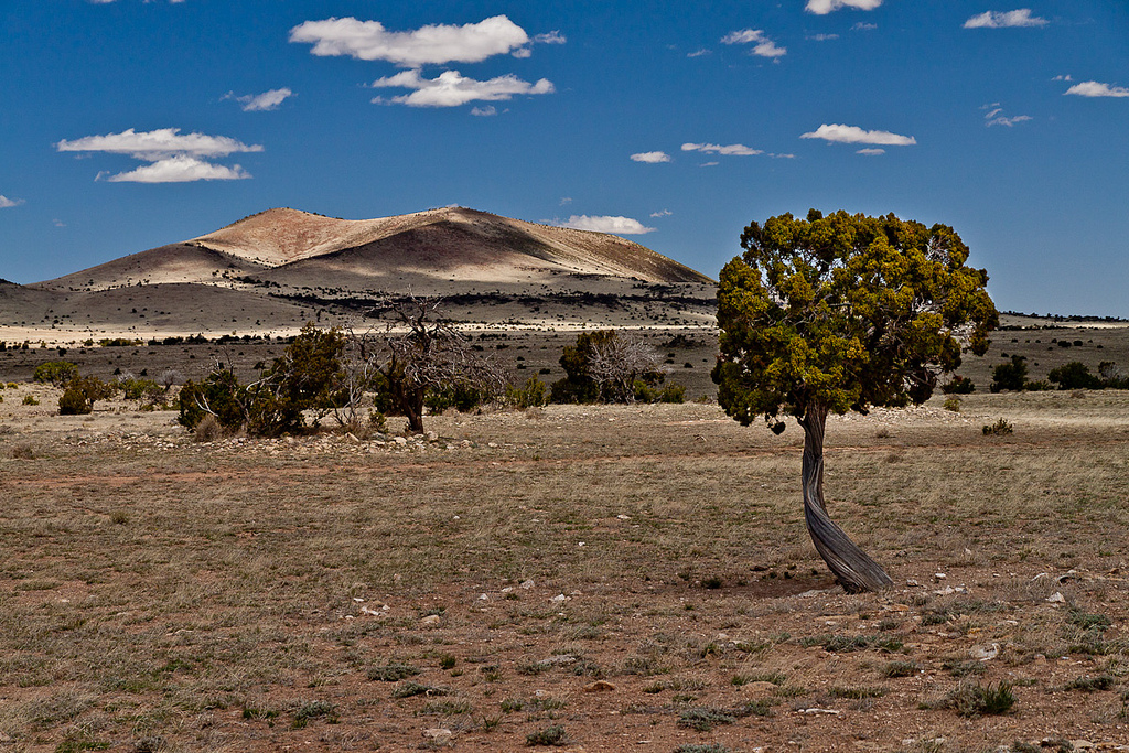
Passage 35 traverses north from Cedar Ranch to Moqui Station through a peaceful and remote part of Arizona. This section passes through two national forests, Coconino National Forest in the south and Kaibab National Forest in the northern section. In between the national forests the trail crosses Babbitt Ranches’ CO Bar Ranch — one of only three private properties along the Arizona National Scenic Trail (AZT).
The trail follows dirt roads and singletrack across gently rolling terrain. It passes through dry grasslands sparsely vegetated with piñon-juniper woodlands, and features a vast landscape with stunning views of the San Francisco Peaks to the south.
This section follows a portion of the historic stagecoach line that once took travelers from Flagstaff to the Grand Canyon, and it ends at Moqui Station, which was a stopover along this route.
Difficulty
- Moderate
Season(s)
- All year. Snow may be present after winter storms
- Current weather forecast
Water
Water can usually be found at the Wildlife Waterer located 1/2-mile east of the AZT near Upper Lockwood Tank Road. Check the online Arizona Trail Water Report for current information at https://aztrail.org/explore/water-sources/.
Notes/Warnings
- All water along this passage should be purified prior to use.
- Babbitt Ranches has granted permission for the Arizona Trail to cross the CO Bar Ranch — one of only three segments of private property along the entire AZT. Babbitt Ranches works to support the Arizona Trail and peoples’ connection with the natural environment, rich history, and wild experiences offered by this region. Please be good stewards of these lands and resources, and respect the people who live and work here.
For more information
- The Passage Steward
- Babbitt Ranches, Inc., P.O. Box 520, Flagstaff, AZ 86002 (928) 774-6199.
- Coconino National Forest, Flagstaff Ranger District, 5075 N. Hwy 89, Flagstaff, AZ 86004 (928) 526-0866.
- Kaibab National Forest, Tusayan Ranger District, P.O. Box 3088, Grand Canyon, AZ 86023 (928) 638-2443.
- BLM Information Center (602) 417-9300.
Current Passage Info

Slate Fire Forces Closure of Arizona Trail north of Flagstaff
June 8, 2021
The Slate Fire has forced a closure of the Arizona Trail north of Flagstaff near Babbitt Ranch. In the interest of public safety, the northern half of AZT Passage 34 (San Francisco Peaks) is currently closed between Kelly Tank (mile 603.3) and Cedar Ranch (mile 616.2). Trail users are discouraged from visiting Passage 35 (Babbitt Ranch) as the fire advances further north. The Slate Fire was first reported on June 7 and has grown to over 11,148 acres (as of June 15). To learn more about the Slate Fire, visit the Inciweb page here.
Read More
