


After 18 months of hard work, our partners at the Coronado National Forest have released the first comprehensive trail plan for the Santa Catalina Ranger District, which includes the northern slope of the Rincon Mountains, Mount Lemmon, Summerhaven and Oracle Ridge. According to Adam Milnor, Recreation, Heritage and Lands Staff Officer for the Forest, the plan includes projects to "diversify trail opportunities, improve sustainability, create new trail connections and boost trailhead access" on the district. A number of the proposed projects will impact Passages 9-12 of the Arizona National Scenic Trail, addressing long standing issues with this well-loved portion of the Trail. These aspirations aren't just dreams, either. Thanks to the recent flow of federal funding from sources such as the Great American Outdoors Act, or GAOA, many of these projects may become reality starting as soon as this winter. The ATA joined the Southern Arizona outdoor recreation community and other trail organizations such as the National Forest Foundation, Tucson Off Road Cyclists and Activists, Santa Catalina Volunteer Patrol, Pima County, Friends of the Santa Catalina Trails and others to help Forest Service staff shape the plan - and we will continue to be involved in it's implementation. ATA volunteers...
Read More
Location
- Redington Road to Gordon Hirabayashi Campground
Length
- 13.2 miles
Resources
- MAP
- PROFILE
- TRACK
- Waypoints: GPS | MP
- Arizona Euro-American History
- USGS Topographic Maps: Piety Hill and Agua Caliente Hill.
- Saguaro National Park map.
- Coronado National Forest map.
- BLM Information Center maps.
Southern Access Point: Redington Road
- GPS Coordinates: 32.30630° N, 110.57428° W
Access
From Tucson, head east on Tanque Verde Road, which becomes Redington Pass Road after you leave the city. The road turns to dirt near mile marker 3. From that point, continue to just past mile marker 12 on Redington Pass Road. At the top of a small ridge the AZT crosses Redington Road. There are AZT signs on both sides of the road.
Northern Access Point: Gordon Hirabayashi Campground
- GPS Coordinates: 32.33581° N, 110.71972° W
Access
Follow Tanque Verde Road east from Tucson and turn left (north) on the Catalina Highway. Drive about 9 miles and pass Molino Basin Campground. Continue 1.7 miles beyond the campground and take the left (west) turn to Gordon Hirabayashi Campground. Drive 0.3 miles to a parking area. Follow a trail out of the south end of the parking lot for 40 yards to reach a “T” intersection with the AZT.
Trail Route Description
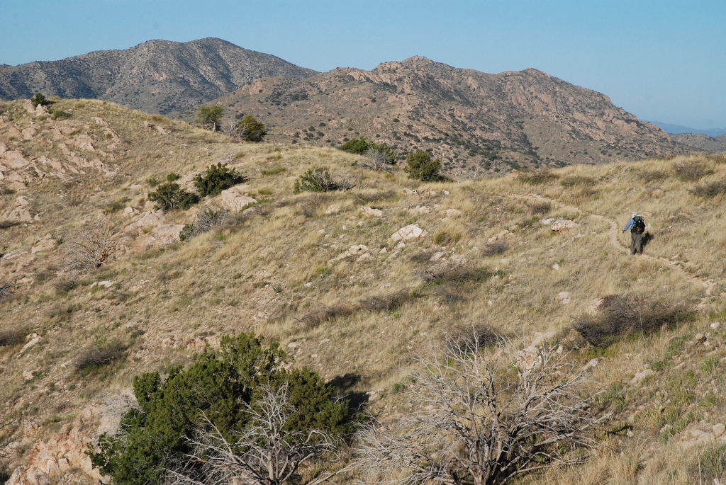
Passage 10 traverses through the transition zone between the Rincon and Santa Catalina Mountains. This section begins in low rolling grasslands with sweeping views of the rounded Rincons to the south. It features golden grasses, rocky hillsides and granite boulders. In the springtime, wildflowers add color to the landscape, especially the tall, purple flower heads of thistle that adorn the trail.
The trail crosses Caliente Creek with shady, large cottonwood trees and a seasonal flow of water.
Scenic singletrack ascends a steep set of switchbacks to a saddle above Molino Basin with panoramic views. To the east is the San Pedro River Valley and the Rincon Mountains, to the west is Sabino Canyon, and to the north-northwest, Mount Lemmon’s sheer granite cliffs reveal the rocky terrain waiting ahead.
There are two campgrounds near the terminus of this section. Molino Basin Campground closes for the summer (usually at the end of April), and the water is shut off at that time. Gordon Hirabayashi Campground is open year-round but has no water.
Difficulty
- Moderate
Season(s)
- Fall, Winter and Spring
- Current weather forecast
Water
Water can be found seasonally at The Lake, West Spring Tank and some of the drainages the trail crosses. In wet seasons, water may be found in the creek in the Molino Basin Campground, but no water is available for campers or hikers. Check the online Arizona Trail Water Report for current information at https://aztrail.org/explore/water-sources/.
Notes/Warnings
- All water along this passage should be purified prior to use.
- This passage of the trail is very popular with mountain bike riders.
For more information
- The Passage Steward
- Saguaro National Park, 3693 S. Old Spanish Trail, Tucson, AZ 85730 (520) 733-5142.
- Coronado National Forest, Santa Catalina Ranger District, 5700 N. Sabino Canyon Rd., Tucson, AZ 85715 (520) 749-8700.
- BLM Information Center (602) 417-9300.
