


World Atlas (May 9, 2024) by Elizabeth Arnold Located in the beautiful American Southwest, Arizona is part of the "four corners" region. The state of Arizona is diverse in many ways, from expansive deserts to sweeping mountain ranges and quiet hometowns and bustling cities. If you're traveling to Arizona, consider checking out one of its many charming small towns for a weekend escape that is either relaxing or adventurous, depending on what you desire. Patagonia The beauty and serenity of the desert surround the small town of Patagonia, which is situated in Arizona's Sonoita Valley. The eclectic town of under 1000 people is located just about 20 miles north of Mexico, so it's heavily influenced by the country's art, culture and food, making it a fun weekend destination to explore. Patagonia also has a strong Western feel due to its historical roots and architectural features. If you're into nature, take a hike or bike ride on the 800-mile Arizona Trail, which runs near Patagonia and gives visitors an up-close look at local desert wildlife, flora, and fauna. The Tucson Audubon's Paton Center for Hummingbirds is another popular attraction, and you can see the highest numbers of small birds between the months...
Location
- Canelo Pass to Highway 82
Length
- 18.1 miles
Resources
- MAP
- PROFILE
- TRACK
- Waypoints: GPS | MP
- Arizona Euro-American History
- USGS Topographic Maps: O’Donnell Canyon, Mount Hughes and Patagonia
- Coronado National Forest map.
- BLM Information Center maps.
- AZT Patagonia trailhead map
Southern Trailhead: Canelo Pass
- GPS Coordinates: 31.51291° N, 110.55819° W
Access
This passage does not feel as isolated as the previous two, but it is seldom used. From the town of Patagonia, follow Harshaw Road (FR 58) east 14 miles to an intersection where FR 58 makes a 90-degree turn to the right. Avoid this turn and continue straight ahead (east) on FR 799. In 5 miles, cross Canelo Pass and continue about 0.5 miles down the other side to a large parking area on the left (west) side of the road. The trail toward Patagonia departs from the right side of a kiosk; the trail arriving from Passage 2 is on the left side of the kiosk.
From the town of Sonoita, follow AZ 83 south for 18 miles to a turnoff on the right for FR 799. Continue 2.9 miles to a parking area on the right that is marked with Arizona Trail signs.
Please note there is no public access to the AZT along Red Rock Canyon Road due to private property and a locked gate.
Northern Access Point: Casa Blanca Canyon Trailhead
- GPS Coordinates: 31°36’1.23″N, 110°43’26.83″W
Access
From the north, follow Highway 82 toward the town of Patagonia. Four miles north of town, turn right/west on Casa Blanca Canyon Road. Follow this dirt road west for 1/4-mile and look for the trailhead on your left/south. Park here, walk through the AZT gate, and follow the Connector Trail for 1/3-mile to locate the Arizona Trail. There is no parking or access along Highway 82; instead please use the Casa Blanca Canyon Trailhead nearby.
Trail Route Description
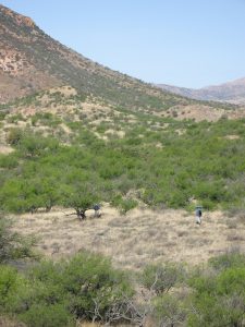
Passage 3 continues north through the Canelo Hills. This section features rolling grasslands, chaparral, and a rich riparian environment. The trail follows a singletrack path that winds up several short, steep hills and through dry wash crossings. Since the area has abundant livestock grazing you’ll see numerous cows and encounter frequent gates.
This section begins with a moderate climb from the Canelo Pass Trailhead up to a saddle with scenic views of rolling hills, shallow canyons and lush grasslands. From here, one is offered panoramic views of the Santa Rita Mountains to the northwest and the Patagonia Mountains to the southwest.
The trail drops into the upper end of Meadow Valley and then continues through rolling hills lined with oak and manzanita. Hundreds of plant and animal species thrive in the nearby Patagonia-Sonoita Creek Preserve which makes it possible to catch a glimpse of a rare, violet-crowned hummingbird, a northern beardless-tyrannulet, or a gray hawk!
Difficulty
- Moderate
Season(s)
- Fall, Winter and Spring
- Current weather forecast
Water
Water may be available at Down Under Tank, Cott Tank Exclosure, and Gate Spring. Red Bank Well generally has water, as it is an important cattle watering location, and uses a solar powered pump. Check the online Arizona Trail Water Report for current information at https://aztrail.org/explore/water-sources/.
Notes/Warnings
- The northern portion of this passage experiences extreme overgrowth in the summertime, and trail work is not permitted before October 1 due to threatened & endangered species that live within the area. Expect difficult route finding, wear long protective layers, and be prepared for extreme conditions if you’re on the trail in the summer and early autumn months.
- Trail is designed for hiking, mountain bikes, and horseback use.
- Cattle grazing occurs along this entire passage. Please close all gates unless they are intentionally wired open.
- Mines are located near some of the trail routes and are marked. Please stay on the trail.
- All water along this passage should be purified prior to use.
- Do not use Red Rock Canyon Road for access.
For more information
- The Passage Steward
- Coronado National Forest, Sierra Vista Ranger District, 5990 S. Highway 92, Hereford, AZ 85615 (520) 378-0311.
- BLM Information Center (602) 417-9300.
